
Nyae Nyae actively monitors fires
Over the past five years, the Nyae Nyae Conservancy and Community Forest has actively managed and recorded fires in their area.
According to a statement issued by the Nyae Nyae Conservancy management committee, this step was taken because fires were causing more damage to the environment than over-grazing.
“Fires were found to be having a major impact and 50% of the 8 992 square kilometre area was devastated and burnt in 2010.”
It became clear that this was not a once-off incident, but a worrying trend that threatens livelihoods, lives and wildlife, the statement said. “The current fires in Australia are a stark reminder of the damage fires can cause and the danger of uncontrolled fires. As climate change takes ahold across the globe, events that used to be rare are becoming an annual or seasonal occurrence.” According to the committee, the Nyae Nyae Conservancy has received professional help in mapping areas most at risk of fires and burning in recent years. These areas are prioritised for fuel reduction burning.
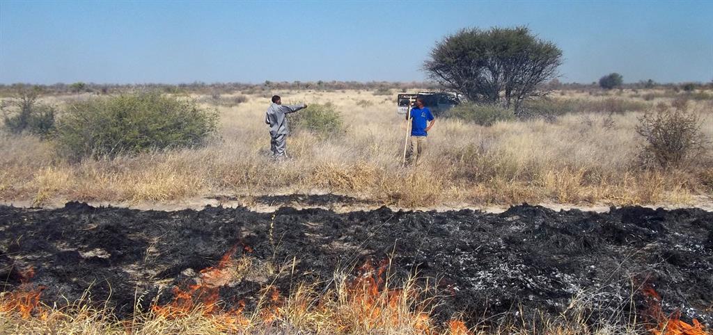
“This controlled burning is carried out to reduce the chances of hotter fires later in the season destroying villages, precious forestry resources and wildlife.”
The committee said the level with which fires can be predicted in relation to mapping and where they occur has been proven very effective.
Last year was perceived as a relatively 'light' year in terms of fires in the Nyae Nyae Conservancy due to the lack of rain and this therefore reduced fuel reduction burning, the committee said.
“However, the end of 2019 brought much-needed and wanted rains in this area and with rainfall already being experienced in January, this will likely lead to 2020 being a year of high fuel growth, and consequently, a year with increased fuel reduction burning activities.”
The committee said this will allow the Nyae Nyae Conservancy and Community Forest to prepare and plan for a month of fuel reduction burning in June and then focus these activities in high priority areas that will be identified and mapped in May. “These activities not only protect villages and save precious resources, but also build on the longitudinal data for this area and enable valuable lessons to be learnt and replicated in other areas where fires are a threat.” The work is being funded by the Environmental Investment Fund.
STAFF REPORTER
According to a statement issued by the Nyae Nyae Conservancy management committee, this step was taken because fires were causing more damage to the environment than over-grazing.
“Fires were found to be having a major impact and 50% of the 8 992 square kilometre area was devastated and burnt in 2010.”
It became clear that this was not a once-off incident, but a worrying trend that threatens livelihoods, lives and wildlife, the statement said. “The current fires in Australia are a stark reminder of the damage fires can cause and the danger of uncontrolled fires. As climate change takes ahold across the globe, events that used to be rare are becoming an annual or seasonal occurrence.” According to the committee, the Nyae Nyae Conservancy has received professional help in mapping areas most at risk of fires and burning in recent years. These areas are prioritised for fuel reduction burning.
“This controlled burning is carried out to reduce the chances of hotter fires later in the season destroying villages, precious forestry resources and wildlife.”
The committee said the level with which fires can be predicted in relation to mapping and where they occur has been proven very effective.
Last year was perceived as a relatively 'light' year in terms of fires in the Nyae Nyae Conservancy due to the lack of rain and this therefore reduced fuel reduction burning, the committee said.
“However, the end of 2019 brought much-needed and wanted rains in this area and with rainfall already being experienced in January, this will likely lead to 2020 being a year of high fuel growth, and consequently, a year with increased fuel reduction burning activities.”
The committee said this will allow the Nyae Nyae Conservancy and Community Forest to prepare and plan for a month of fuel reduction burning in June and then focus these activities in high priority areas that will be identified and mapped in May. “These activities not only protect villages and save precious resources, but also build on the longitudinal data for this area and enable valuable lessons to be learnt and replicated in other areas where fires are a threat.” The work is being funded by the Environmental Investment Fund.
STAFF REPORTER

Comments
Namibian Sun
No comments have been left on this article